Menu   ≡ ╳
  • Home
  • News
  • Products
    • AEMP-14
    • Geovizer
    • SibER 48
    • SibER 48K12
    • SibER 64К15
    • ERTLab
    • LandMapper ERM-02
  • Application
    • Archeology
    • Ecology
    • Engineering geology
    • Agronomy
    • Special Usage
  • Support
    • FAQ
    • Video instructions
    • Downloads
    • Knowledge
    • Warranty Policy
  • Service
  • Information
    • About Us
    • Partners and clients
    • Press
    • Gallery
    • Links
  • Contacts

Archeology Localization and detailed study of archaeological sites, etc. Road construction and inspection Engineering-geological surveys, localization of underground utilities, structures, etc. Precision Agriculture Fertility assessment, monitoring the spread of groundwater dynamics, assessment of concentration of mineral fertilizers, etc. Building construction and inspection Engineering-geological surveys, geophysical surveys under the foundation of buildings, monitoring of underground communications, etc.

Home

Electromagnetic induction profiling tools:

Compact EM-I profiler Geovizer
Multi-frequency EM-I profiler AEMP 14
EM-I profiler Geovizer
EM-I profiler AEMP 14

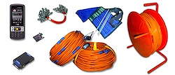
Electro-tomography and induced polarization equipment:
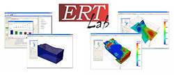
One channel complex  “SibER 48”
16-channels complex “SibER 64”
RT, VES
ERT, VES
 12-channels complex “SibER 48К12”
Accessories and related products
Cable, clips, electrodes, spare parts, additional equipment

Inversion software:

3D inversion – ERT-Lab
2D inversion –ZondRes2D
ERT-Lab

Partners products:

LandMapper ERM-XX
TerraZond 3D-GPR GRT-ХХ
Landviser LandMapper ERM-XX

Geophysical survey:

We offer our services to organize and conduct field works using different geophysical methods, to process and interpret data.
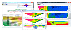
Our experts have extensive experience in performing a wide range of geophysical problems, including composition of several methods – electrical (Electromagnetic Frequency Induction Sounding – EMF-IS, vertical electrical sounding – VES, dipole electrical sounding – ECD, VC, 2D and 3D imaging), seismic and magnetic exploration.

Scope of applications:

• Archaeological survey;
• UXO determination;
• Subsurface tunnels and empties investigations;
• Quantitative assessment of water saturation of the ground;
• Assessment of HC waste in the ground;
• Searching both fresh and salty water source;
• Subsurface buildings condition control;
• Searching and localization of burial place of industrial waste;
• Source and volumes of water leakage in water supply and heating systems;
• Source and volumes of fuel/oil leakage in subsurface fuel tanks/pipelines;
• Definition of places of a lining of metal pipes and cables;
• Detail exploration of ore bodies;
• Environmental monitoring of dumping liquid mineralized waste.


    ruen
  • Новости

    • QZond and iiSystem ver.4
    • “Georadar-2019”
    • “GeoEurasia-2019”
    • Updated instruction manual for AEMP-14
    • “Engineering and Mining Geophysics 2018” (EAGE)
    • Youtube channel
    • New updates of QZond and iiSystem
    • Conference “Georadar-2017”
    • Real-time localization system RTK GNSS for EM-I scanners
    • New application for Android to control EM-I devices

  • Контакты

    Телефон в Москве:
    +7 (495) 789-49-89

    Телефон в Новосибирске:
    +7 (383) 227-84-21

© Все права защищены Nemfis™ 2008-2019
© All rights reserved Nemfis™ 2008-2019
RSS  
CALL ME
+
Call me!